This wildfire evacuation checklist that could save lives this season

WFCA publishes wildfire evacuation guidance

The Western Fire Chiefs Association (WFCA) has released detailed guidance on what to do before, during and after a wildfire evacuation.

The WFCA said the aim is to help families, property owners and communities stay safe as wildfire seasons become longer and more frequent across the US.

The organisation explained that the best time to prepare for a wildfire evacuation is before one begins.

Its guide outlines essential preparation steps, evacuation procedures and safety checks for returning home after an evacuation.

Preparing for a wildfire evacuation

According to the WFCA, early preparation can make evacuation faster and safer when wildfire threats arise.

Households are advised to create an emergency ‘Go Bag’ containing essential supplies such as water, food, medication, cash and copies of important documents.

Each bag should include at least three gallons of water per person, three days’ worth of non-perishable food, a first aid kit and a flashlight powered by batteries.

The WFCA also recommended including pet food and water for animal companions.

Residents are urged to learn local evacuation routes and consider backup routes in case primary roads are blocked.

Plans should also include transportation for pets, livestock and service animals, along with accessible shelter options.

The WFCA said it is important to account for people in the household who may need extra assistance due to mobility, hearing or vision challenges.

Creating a communication and reunification plan with family members can prevent confusion if phone lines are down or household members are in different places during the evacuation.

What to do when an evacuation is issued

The WFCA explained that local authorities will use a three-level alert system for evacuation orders.

A Level 1 notice means ‘Ready’, Level 2 means ‘Set’, and Level 3 means ‘Go – Now!’.

Mandatory evacuation orders must be followed immediately, the organisation said.

When leaving a home, residents should close all doors, windows and vents to reduce radiant heat and drafts.

The WFCA advised switching on exterior and interior lights to make the home more visible in smoky conditions.

It also recommended moving flammable furniture indoors, filling large outdoor containers with water and turning off natural gas lines.

Homeowners should disconnect automatic garage door openers to allow for manual operation if power is lost.

The WFCA said that residents should check on neighbours who might struggle to evacuate and contact emergency services if anyone cannot leave on their own.

Returning home safely after an evacuation

Residents should only return once local authorities have confirmed that it is safe to do so.

The WFCA warned that hazards may remain even after a wildfire has passed.

Homeowners are advised to inspect their property carefully for damage and check for structural stability.

Utility companies should be contacted to report leaks or damaged infrastructure.

The WFCA said that landscaping should also be checked for falling trees or damaged fencing that could pose safety risks.

Homeowners are encouraged to document any property loss by taking photos or videos before contacting their insurance providers to begin the claims process.

Building long-term wildfire resilience

The WFCA said that fire-resistant landscaping and defensible space are key to reducing the risk of future wildfire damage.

Defensible space involves clearing combustible materials, using non-flammable building materials, and creating distance between vegetation and structures.

Techniques include removing debris, using stone or gravel for hardscaping, and selecting fire-resistant plants with high moisture content and deep roots.

The WFCA added that communities can further strengthen preparedness by developing a Community Wildfire Protection Plan (CWPP).

CWPPs are collaborative strategies developed by residents, local agencies and government bodies to address wildfire risks specific to their area.

The WFCA advised residents to register for local wildfire alert systems and stay informed through official communication channels.

Relevance for fire and safety professionals

Wildfire evacuation preparedness and recovery planning are directly relevant for fire and rescue services, emergency management professionals and local government safety planners.

The WFCA guidance offers structured evacuation procedures that align with community protection strategies used by incident commanders and emergency planners.

Its recommendations on defensible space and fire-resistant landscaping provide practical measures that can reduce risk for property owners and support prevention work led by fire departments.

Emergency managers, fire chiefs and local authority safety officers can reference this material when updating public education campaigns and community wildfire protection plans.

Building and landscape engineers involved in wildfire-prone regions may also use the guidance to support resilience-focused design and planning.

This article was informed by information from the following source: The Western Fire Chiefs Association (WFCA)

From spark to inferno: Wildland fire mitigation strategies

As wildfire takes over the globe, WFCA Senior Policy Advisor Bob Roper navigates the complex terrain of wildland fire policy development and mitigation strategies

The world’s attention is riveted on the increasing threat posed by wildfires, a global issue that has been amplified exponentially by the spectre of climate change. Recent developments underscore the severity and global scale of this escalating crisis. From the vast wilderness of Canada to the diverse landscapes of Europe, the wildfire threat casts a long, ominous shadow.

In Canada, an unprecedented wildfire season has been unfolding, triggered by a heat dome that caused temperatures to soar to unheard-of levels. This extreme heatwave, a direct consequence of climate change, has ignited hundreds of wildfires across British Columbia, Alberta, and other provinces.

The fires have incinerated vast swaths of forests, destroyed properties, and claimed lives. Toxic smoke from these wildfires has not only choked Canadian cities but has travelled thousands of kilometres to reach as far as Europe, underscoring the transcontinental reach of this crisis.

Meanwhile, across the Atlantic, Europe is grappling with its own wildfire challenges. A deadly heatwave, dubbed “Lucifer,” has been sweeping across the continent, triggering a spate of wildfires from Spain to Greece. Climate scientists are unambiguous about the role of climate change in these extreme weather events.

The continent is seeing its temperature records shattered, and the scorching heat has turned vast tracts of vegetation into tinderboxes ready to ignite. The wildfires in the Mediterranean, known for their holiday destinations, are also threatening lives, homes, and the region’s valuable tourism industry.

The intersection of climate change, extreme heat events, and wildfires has created an inferno of catastrophe. It paints a dystopian portrait of a future where uncontrollable wildfires could become an annual event, drastically impacting ecosystems, human health, and economies.

This harsh reality is also evident in the United States, which grapples with its own unique challenges. The interplay of climate change, land-use practices, and an increasingly complex electrical infrastructure has created a unique tinderbox for wildfires. A confluence of factors, including drought conditions, rising temperatures, and human activity, has created a perfect storm for the wildfires.

Mitigating this crisis calls for a global response, and importantly, expert insight and guidance. As we dive into this looming threat, we sought the expertise of someone deeply embedded in the heart of this issue – Bob Roper.

Roper, with a career spanning over 45 years in the fire service and wildland fire policy development, has worked in various roles from Ventura County Fire Department Fire Chief to State Forester for Nevada. Currently, he is the wildfire policy advisor for the Western Fire Chiefs Association, where he focuses his expertise on strategic planning and public policy related to Wildland Fire issues. In our conversation, Roper sheds light on the complexities of wildfire prevention, the role of electrical utility vendors, and his vision for the future of wildfire mitigation.

As our understanding of the complexities deepens, it underscores the pressing need for strategic responses to manage and navigate this escalating threat. We sat down with Roper to these explore challenges in depth, providing insight into the complexities of wildfire prevention, the role of electrical utility vendors, and his vision for the future of wildfire mitigation.

What drove your decision to focus specifically on wildland fire policy issues?

Coming up through the Ventura County Fire Department, I had the pleasure to work with some of the founding members of FIRESCOPE. FIRESCOPE was created in the early 70’s to address issues involving common operational procedures and organization of emergency incidents. Thus, the Incident Command System (ICS) was born. My work experience focused on wildfires as I found that if an agency can command a dynamic moving wildfire incident, that agency can successfully handle most any other type of emergency incident.

I soon became involved in local wildfire policy development which dictated state policy coordination. This compounded and I soon became involved in the International Association of Fire Chiefs’ Wildland Fire Policy Committee, which created the opportunity to evolve into national policy interaction. It was through these collective experiences that I found the integral nature of how policies at all levels must work up and down for success.

How have you seen the strategies for handling wildfires evolve, especially with the advancements in technology?

Technology and procedural changes always enhance our overall success, but the real secret to success is getting the right players to the table to discuss and create good policy. These players need to understand all perspectives and remove the barriers to success while focusing on the goals.

We have seen top-down policy at all levels get enacted, but the degree of success actually lies with the performance of the policy at the field level. We also cannot rely on policy being adopted without proper education and marketing of consequence management. So, technology is not the be all end all – it becomes the supporting tool to make policies successful.

Can you discuss challenges and achievements in wildland fire policies across local, state, and federal levels?

When addressing the local, state, and federal policy levels, it really boils down to a matter of perspective. Example, Ventura County has a model Hazard Reduction program that builds defensible space. Its success rate speaks volumes, but it was built on local community relationships and hard data to gain the needed political support.

This program became a model for CA, but the enforcement program has not gained the same success rate. This is because of the exponential nature of education and outreach needed to have the same success as Ventura County did.

This situation is further exacerbated at the federal level when you do not have the same community bonds that the local level has. This is why the wildfire problem cannot be a one-size-fits-all approach. Success relies on a common vision and/or an enforcement program to force compliance rather than rely on intrinsic values.

How do electrical utility vendors’ transmission systems contribute to wildfire ignitions, and how significant is this issue?

Utility systems are an essential part of our daily lives, but everything needs to be maintained. These systems can produce trouble faults from arcing, heat exposures and critical failures due to age, accidents (traffic accidents) and acts of nature (trees into lines and animal ground faults). Serious consideration has been made to evaluate the cost of undergrounding the transmission and distribution systems, but that mitigation option can be cost prohibitive.

This becomes a conundrum where we ask: “What is the financial pain tolerance in utility bills to upgrade systems vs. what are acceptable wildfire losses?” It’s interesting that electrical utility caused wildfires only account for 7-10% of all wildfires. It’s just that many of the high-profile wildfires recently have been attributed to electrical utility ignitions.

What are some of the potential pitfalls of vendors being left in charge of their own system monitoring?

It’s always best to have all parties practice full transparency, so public trust is maintained. We must recognise that technology isn’t foolproof, leading to false positive trouble reports that can undermine our trust in it. However, as these systems improve over time and our confidence grows, this creates a corresponding dependence on them.

Can you explain how a state warning control centre might utilise technology to monitor these transmission systems more effectively?

By a state warning centre or equivalent having this type of data, utility companies can ensure that they have the best data available to mitigate potential ignition starts. This type of data also provides an overwatch display for the respective governing entity. The real secret in this type of data is the elimination of false positives, so there is a high degree of reliability for response.

How might such monitoring help in pre-positioning emergency resources before adverse wildfire weather conditions are present?

In many cases today, when actual or anticipated incidents occur, resources are staged or prepositioned on a regional basis. This type of reliable data can locate scarce resources to a latitude/longitude location to verify a trouble spot or be in the immediate area pending a utility response. If an ignition does occur, hopefully it can be controlled much faster than from a regional response location.

What are some strategies or methods you recommend for mitigating the risk of wildfires in areas with high-density electrical utility infrastructures?

It starts with a wildfire mitigation plan. These plans detail probable areas, control actions and updates to the infrastructure. Maintenance of the infrastructure is key and improves the system’s performance while reducing liabilities.

Identifying the probable areas of ignition also allows a utility to consider how they might want to restructure grids to lessen the impact of a Public Safety Power Shutoff (PSPS). Also, many utilities have created their own response capabilities ranging from watch patrols to firefighting resources. In addition to these steps, I strongly urge utilities and their respective fire response agencies to enhance their relationships.

What is your vision for the future of wildland fire prevention?

We are currently witnessing an increase in wildfires due primarily to extreme wind conditions. We are also seeing utilities doing an amazing amount of infrastructure upgrades. My vision is that we will see the utility caused wildfire data flip-flop as utility infrastructure improvements become reality.

How can we better educate the public and private sectors about these issues, and what role can they play in wildfire prevention?

We must provide an on-going education message that the wildfire challenges are not one entity’s issue, it is the collective challenge to government, private sector, and the public at all levels. We need to form a common bond that enables all of us to focus on the right solutions for our communities.

That being said, there are general guidelines that each community can use to address their specific challenges. We also need to understand that wildfires have been part of our ecosystems for centuries and we must learn to live with wildfires as part of our culture today and into the future.

This exclusive article was originally published in the September 2023 issue of International Fire & Safety Journal. To read your FREE digital copy, click here.
From Paradise to Maui wildfires: understanding the challenges and seeking solutions

In a recent comment article for the Western Fire Chiefs Association (WFCA), Mark Niemeyer, President of the Boise Fire Department, shared his observations on the devastating wildfires in Maui in light of the 2018 Camp Fire in Paradise, California.

Drawing comparisons and contrasts between the two incidents, Niemeyer offers insight into the challenges faced and the resilience of both communities.

Read the original commentary here.

Paradise and Maui: a tale of two fires

As Niemeyer recounted: “As I watched the tragic wildfires unfold on Maui, I reflected on the 2018 Camp Fire that swept through Paradise, California.”

Both incidents were characterised by significant loss of life and property, coupled with a strong sense of community spirit and resilience.

The Camp Fire rapidly mobilised a vast amount of emergency resources.

In contrast, Maui’s geographical limitations posed challenges in accessing resources, emphasising the importance of holistic initiatives to mitigate losses in Urban Interface fires.

Both fires broke out in densely populated areas, fuelled by dry conditions and extreme winds, and were exacerbated by limited access routes.

Niemeyer states that: “Utility/communications infrastructure damage prevented notifications, resulting in an urban conflagration and record-setting loss of life and property.”

Addressing the challenges: the role of technology and preparedness

It’s vital to understand that sometimes incidents can surpass the capacity of even the best-equipped responders.

Niemeyer observes, “In both Paradise and Maui, the public had some of the most capable, well-trained and well-equipped first responders.”

However, sometimes, circumstances escalate beyond manageable levels. This was evident when residents were caught off-guard due to compromised communication infrastructures.

To enhance wildfire public safety, Niemeyer listed several technological advancements led by WFCA and other first responders.

These include planning, applied sciences centres, detection tools, alerts, and more.

He stressed the significance of technology in improving situational awareness during extreme emergency incidents.

Looking forward: the importance of resilience and policy

The aftermath of these tragedies calls for a contemplation on resource allocation and the extent of preparedness, response, and recovery efforts required.

Niemeyer emphasises: “The bottom line is we – including the public, government entities, and non-government organisations – need to be prepared for the anticipated and unforeseen emergency incidents.”

Acknowledging that some emergencies might be beyond control, Niemeyer urges that resilience be built into both public and private spheres.

IFSJ Comment

The ongoing challenges posed by wildfires, as seen in both Paradise and Maui, underline the necessity for robust, adaptive, and technologically advanced responses.

Mark Niemeyer’s reflection on these incidents offers vital insights into understanding the scope of such emergencies and the steps required to tackle them effectively.

It also sheds light on the interplay of various factors, including geographical constraints, community resilience, and technological advancements in formulating effective disaster management strategies.

About Western Fire Chiefs Association (WFCA)

The Western Fire Chiefs Association is dedicated to promoting leadership and addressing the unique needs and challenges faced by fire chiefs across the region.

Committed to advancing public safety through collaboration, knowledge-sharing, and advocacy, WFCA continually endeavours to optimise the firefighting domain by providing resources, training, and a platform for dialogue among its members.

WFCA joins hands with Cal Poly’s Wildland-Urban Interface FIRE Institute in strategic alliance

The Western Fire Chiefs Association (WFCA) has announced a collaborative effort with the Wildland-Urban Interface FIRE Institute at California Polytechnic State University, San Luis Obispo.

This partnership aims to foster innovation and enhance public safety in the Wildland-Urban Interface regions.

A united front for Wildland-Urban Interface challenges

According to WFCA’s official news release, the WFCA’s Applied Sciences Center functions as a bridge between various sectors, including industry, business, non-profits, and academia, to support mutual projects and bolster the public service innovation ecosystem.

The WUI FIRE Institute, part of California Polytechnic State University, is a renowned interdisciplinary university centre that has been deeply engaged in Wildland-Urban Interface research for several years.

In recognition of Cal Poly’s dedication to the WUI FIRE Institute, the WFCA has contributed a $54,000 donation to bolster the Institute’s endeavours.

Addressing Wildland-Urban Interface complexities

Both institutions acknowledge the intricate and significant challenges posed by the Wildland-Urban Interface. WFCA Chief Executive Officer, Jeff Johnson, stated: “The Cal Poly WUI FIRE Institute has an industry reputation for responsive applied research.

“Their strategic framework is comprehensive, achievable, and will improve outcomes on the ground where it matters most.

“Our practitioner-academic alliance will yield the practical and evidence-based solutions our public and private sectors expect and need from us.”

WUI FIRE Institute Director, Frank Frievalt, echoed this sentiment: “The WFCA is renowned for its innovation and thought leadership in the Wildland-Urban Interface for local government fire agencies in the western US.

“This alliance will contribute to a new Framework for Strategic Wildland-Urban Interface Mitigation.”

The combined efforts of both entities will ensure a strategic approach in addressing the increasing wildfire threats.

“It is clear that simple suppression is not the solution.

“Effective, evidence-based policy decisions, and comprehensive mitigation strategies are required for long-term resilience in Wildland-Urban Interface communities.

IFSJ Comment

The strategic alliance between WFCA and Cal Poly’s WUI FIRE Institute marks a significant step towards addressing the growing challenges in the Wildland-Urban Interface.

Their shared mission and expertise present a formidable front against the escalating wildfire threats.

By combining academic research with practical application, this partnership exemplifies how collaborative efforts can pave the way for enhanced community resilience, well-informed policy decisions, and innovative mitigation strategies.

WFCA unveils Applied Sciences Center for Resilience Studies to bridge research and practice

A pioneering effort for resilience

The Western Fire Chiefs Association (WFCA) has revealed a significant initiative to support and enhance resilience across various sectors.

In a landmark move, WFCA has launched the Applied Sciences Center for Resilience Studies (ASC), aimed at creating a connection between research and practice.

The ASC is envisioned as a collaborative platform involving communities, government bodies, industries, and academia.

Its purpose is to foster resilience within society through focused research and development initiatives.

Resilience against wildfires: the inaugural research

Backed by funding from NASA’s Science Mission Directorate’s Earth Science Division, the ASC’s first research project is centred on improving wildfire technology and decision-making processes.

This effort aims to create a flexible decision matrix and model to assess investments in wildland technologies, doctrine, and operations.

The ultimate goal is to enhance the first responders’ ability to adapt to the evolving challenges of increased wildfire threats.

The vision for this project has been jointly developed with the Moore Foundation and former State Fire Marshal of California, Chief Kate Dargan, in reaction to the mounting threats of wildfires and the difficulties of acquiring actionable intelligence.

Dr. Katelynn Kapalo and co-investigator Brian Collins are leading this initiative.

They are focusing on identifying essential technology investments for the initial 24-hour response to wildland-urban interface fires.

“Our central goal is to support incident management teams making decisions in dynamic and changing environments where intelligence gathered and resource management is critical to the decision-making process,” said Collins and Kapalo.

For this venture, ASC will partner with Processus and Obsidian, leveraging data and decision science expertise used across military, training, and medical fields.

Commitment to innovation and resilience

ASC Director, Chief (ret.) Bob Horton, voiced his enthusiasm for the approach: “We are proud to have the confidence of NASA to conduct this important work.

“Our role is to connect the research community and experts from other domains to practitioners on the ground.

“This initiative will directly benefit our firefighters and offer guidance to academia and industry alike, spurring innovation and progress.”

WFCA President Mark Niemeyer marked the occasion, saying: “The WFCA is expected to bring innovation into the fire service.

“The ASC shows our commitment to doing just that, and we are excited to be unveiling it, and looking forward to announcing our new partners and projects in the coming weeks.”

For more details about the Applied Sciences Center for Resilience Studies and the Western Fire Chiefs Association, please visit here.

IFSJ Comment

The launch of the Applied Sciences Center for Resilience Studies by WFCA signifies a remarkable step in unifying practical application with scientific research.

By targeting both wildfire technology and broader resilience strategies, this effort promises to drive innovation and contribute significantly to the knowledge base, empowering communities, firefighters, and first responders.

WFCA partners with Milliman to drive down risk of Wildland-Urban Interface

The Western Fire Chiefs Association (WFCA) has entered a strategic alliance with Milliman, a global leader in risk management, to drive down risk in the Wildland-Urban Interface (WUI). 

Milliman has an established expertise in WUI risk analysis through extensive work for its property insurance clients. Together, the organisations have the confidence, experience, and humility, to recognise the complexity and consequential magnitude of the WUI problem, including requiring the external expertise. 

The WFCA said that WUI communities are facing, and will continue to face for decades to come, extraordinary wildfire threats from a perfect storm of ecologic, economic, and climatologic forces, and it is impossible to “suppress” our way out of these conditions. 

Instead, they hope to induce persistent resilience in WUI communities through the adoption and maintenance of evidence-based mitigations at scale. The Association said that there is shared interest between the fire and insurance professions of zero property loss to property owners from the peril of wildfire is powerful and laid down its intent to bookend support for effective mitigations between them and minimise the barriers to implementation by property owners through public and private means.

WFCA Executive Director, Jeff Johnson said: “Milliman is a preeminent worldwide leader in the insurance and risk space. We can only rely on best of class collaborators like Milliman, who offer actuarial projections into the future, to help engineer our way out of the current wildfire property loss trajectory.  We have established this strategic alliance after several years of tightly focused tactical collaboration with Milliman that has consistently yielded high quality and implementable results within the property insurance space.”

Nancy Watkins, a principal and consulting actuary with Milliman, added: “At the end of the day actuaries and fire chiefs are trying to solve the same problem – to understand wildfire risk and figure out the best ways to reduce it. With this alliance, we’re combining the WFCA’s on-the-ground leadership with Milliman’s deep insurance and modeling expertise to create an innovative and holistic approach to measuring, communicating, and reducing wildfire risk.”

Bringing our combined expertise to bear, WFCA and Milliman will help mitigation efforts evolve from analysis to intelligent management and purposeful disruption of the fire pathways that enable disastrous conflagration in WUI communities. 

Western Fire Chiefs Association introduces phase 2 of its wildland fire map

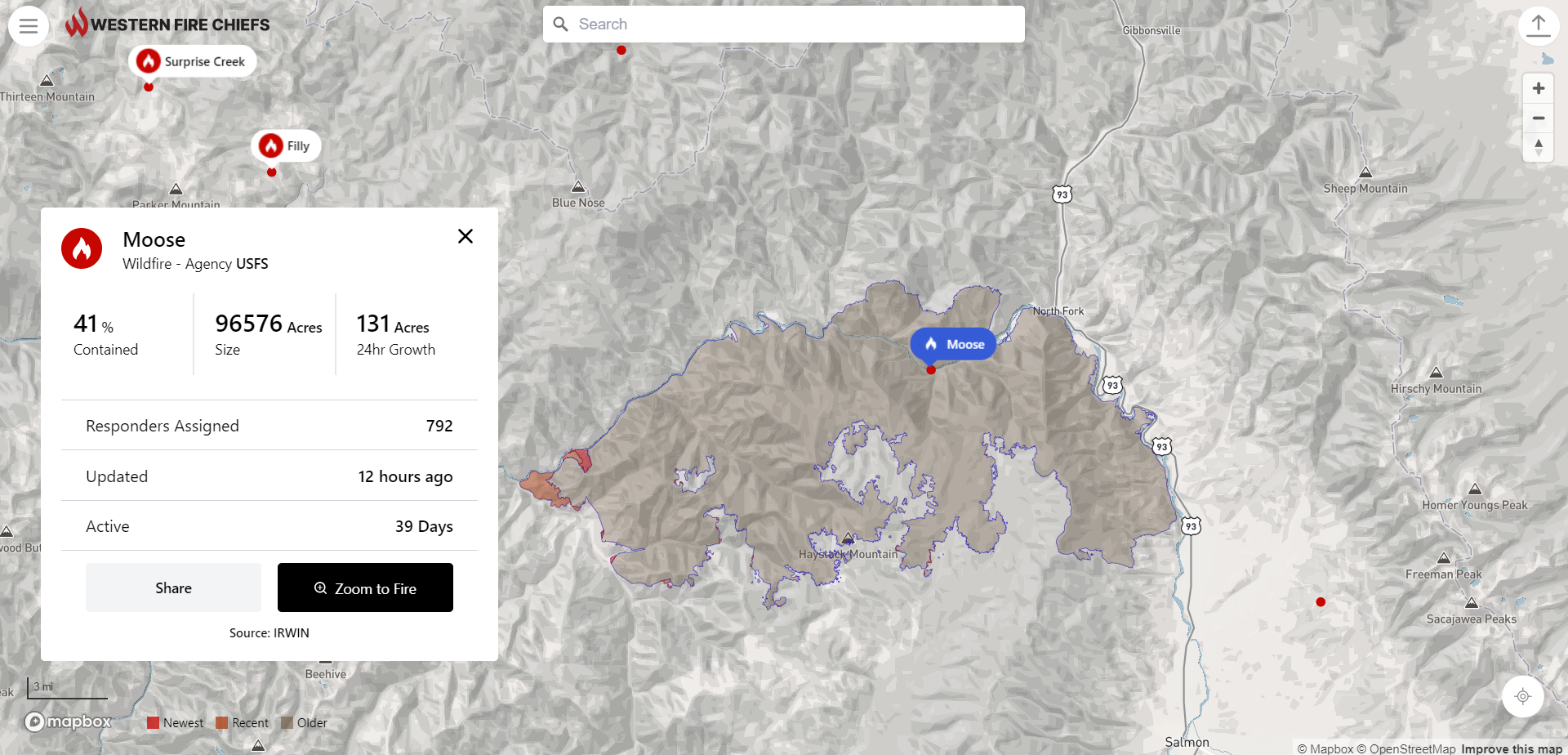
The Western Fire Chiefs Association (WFCA) has announced the introduction of Phase 2 of its Fire Map, which launched in July this year. Phase 2 now includes 3D map views, reporting of active fire-fighting aircraft in real-time, and Fire Integrated Real-Time Intelligence System (FIRIS) specific to the state of California, providing a higher level of detail to keep lives, land, and property safe.

The WFCA Fire Map is the first of its kind to integrate real-time flight mapping of fire-fighting aircraft. The Forest Service uses aircraft to track, manage, and fight wildland fires.

This includes aerial supervision aircraft that communicate with firefighters on the ground, air attack aircraft coordinating aerial firefighting, air tankers with the capability to deliver up to 8,000 gallons of fire retardant, water scoopers, and smoke-jumper aircrafts. Fire Suppression Aircraft are depicted on the WFCA Fire Map, with aircraft type, speed, and altitude.

Said Brent VanKeulen, Deputy Director, WFCA, said: “Wildland fires are often at their most dangerous when they first start. This information will significantly impact the speed in which we can get information out to the public, and will also provide a more detailed and richer level of visual communications to communities at risk.”

Clicking on an individual aircraft will reveal the aircraft’s recent flight path indicating where current fire-fighting activity is taking place. The WFCA Fire Map is also the first to depict Wildland Fire activity in 3D, where the viewer can rotate their vantage point around the fire map and view the fire from 360 degrees.

Specific to California, the WFCA Fire Map will integrate fire-perimeter data provided by FIRIS (Fire Integrated Real-time Intelligence System) and will be the first to do so.

FIRIS is a public-private partnership that provides real-time intelligence data on emerging incidents in California. Funded by the California Office of Emergency Services, the funding supports aircraft, a common operating picture, and near-real-time fire modelling that is available at the onset of emerging incidents.

Brian Fennessey, founder of FIRIS, California Fire Chiefs Fire Chief of the Year, and Orange County Fire Authority Chief, said: “FIRIS provides real-time situational awareness for firefighters on the ground, helping them make critical decisions. I believe that the same information helps the public, too. That is why we have partnered with the WFCA.

FIRIS began in 2019 and uses the Overwatch Imaging platform, which includes an aerial infra-red (IR) platform that integrates cutting-edge technologies provided by Aevex Aviation. That data is fed to Intterra’s wildfire decision support software where WIFIRE retrieves the data for predictive analytics.

Exclusive: The WFCA is putting wildfire on the map

Take an inside look at the Western Fire Chiefs Association’s new Fire Map which provides near real-time information about active wildfires

Whilst they are no new phenomenon, with the number of wildfires increasing across the world the danger is closer to home for many. The mounting wildfire crisis in the US presents a very real and significant danger to people, homes, and communities – particularly those in wildfire urban interface settings.

Fires are most likely to take hold when moisture levels and humidity are low and temperatures are high. These conditions can be exacerbated by climate change and when environmental conditions reach a certain threshold in terms of available fuel and dryness, the risk of intense and dangerous fires can increase quickly. In response to the rising temperatures and increased risk of fire the Western Fire Chiefs Association (WFCA) introduces its Fire Map to provide near real-time information about active wildfires.

The WFCA Fire Map pulls data from the US Forest Service via National Interagency Fire Centre IRWIN feed and 911 Dispatch data via PulsePoint to track the location of the wildfire as they start and while they are burning. The WFCA Fire Map is the first map of its kind to pull this data from 911 Dispatch in relevant areas.

“The current climate situation is incredibly scary,” says Chief Mark Niemeyer, Vice President of the WFCA and Fire Chief of the Boise Fire Department. “The WFCA is providing public access to definitive information around the paths of wildfires so that communities can quickly take action.”

He continues: “The WFCA is committed to provide an even deeper level of intelligence around wildfires as they happen.” As the WFCA looks to the future, it is creating a development path in the next year which will include 3D and predictive mapping models, air quality and weather data, as well as text message notifications.

The Fire Map

The WFCA Fire Map was launched to provide near real-time information about active wildfires in a mobile[1]friendly platform. Brent VanKeulen, Deputy Director of the Western Fire Chiefs Association says the WFCA is providing the map to everyone free of cost, as a resource to save lives, land and property. He explains: “By providing public access to definitive information around the paths of wildfires, we are hopeful that communities can take quicker action to stay safe.”

 The WFCA Fire Map pulls together data supplied by the US Forest Service via National Interagency Fire Center IRWIN feed and combines it with 911 Dispatch data via PulsePoint. Together, this information is used to track the location of the wildfire both as it starts and whilst it is burning.

 The fire map was developed by Gartrell Group for the WFCA. Users can search for a fire by name, zoom to a location or zoom to their location and explore the area nearby. Where larger fires are mapped these will display the perimeter as changes are reported. Along with the map visualisation, the app provides details including fire size in acres, 24-hour growth, percent containment, number of personnel assigned, how long the fire has been active, and when the information was last updated.

The app features a share button and clicking this allows users to easily share information about a fire. There is also an embed option to link to a live map of the McKinney Fire. Users can click the fire symbol on the map to view information about the fire, and to share to social media. Other features such as weather and wind information are in the pipeline.

Looking ahead, the fire map in its current state is just the beginning. VanKeulen adds: “Wildfires will be a part of our lives for the foreseeable future. We will always have areas where people live in the forest. We need to focus on building adaptive communities so that we can be safe in the presence of fires. The WFCA and many other organizations are working towards solutions that help us adapt. The fire map is one of several initiatives.

PulsePoint

PulsePoint is a 501(c)(3) public non-profit foundation building applications created to help public safety agencies inform and engage their citizens. The development of the PulsePoint app began in June 2009 as a partnership between the San Ramon Valley Fire Protection District (SRVFPD), where its founder Richard Price was the chief, and the College of Informatics at Northern Kentucky University (NKU).

The application was released in the Apple App Store in April 2010. At a meeting almost a year later the Board of Directors of the San Ramon Valley Fire Protection District established a committee to address the affairs related to the application, including the transfer of responsibility for the software to an independent and external non-profit foundation. This resulted in the formation of the PulsePoint Foundation to oversee the future direction of the application.

In September 2013 the PulsePoint Foundation entered into a strategic partnership with Physio-Control, Inc. to expand the availability of PulsePoint to public safety agencies and on January 1, 2017, these responsibilities transitioned back to the foundation. Physio-Control became an invaluable partner that helped establish a presence in the market and helped prove the value of using mobile technology to activate early bystander response in sudden cardiac emergencies.

As the WFCA looks to the future, it is creating a development path in the next year which will include 3D and predictive mapping models, air quality and weather data, as well as text message notifications. “The addition of text notifications will be a game changer.” Richard Price, Founder PulsePoint.

“We are excited to offer the opportunity for PulsePoint[1]connected agencies to seamlessly display fire incidents within the WFCA Fire Map.”

This article was originally published in the September edition of IFSJ. To read your FREE digital copy, click here.