Portugal asks Europe for help ahead of 2023 fire season

Portugal has applied for European support to have more aerial support to fight fires in the summer of 2023, according to The Portugal News.

During a seminar on the 2022 rural fire season, José Luís Carneiro, Minister of Internal Administration of Portugal, said: “We have just applied for European Union funds for additional aerial firefighting assets that could be part of the rescEU [European Civil Protection Mechanism instrument] transition fleet for the summer of 2023, and I am convinced that we will complete this process with great success.”

Carneiro also said that Portugal is still available to receive one of the four pre-positioning centres for air, land and human resources that the European Union plans to make available in parts of Europe.

The minister said that he had spoken with the Minister of the Interior of Spain to point out that there is in Castelo Branco an air and logistical means centre: “That has logistical infrastructure conditions to support, not only the national territory, but to support the countries of the Mediterranean and also to support Spanish territory”.

Carneiro added: “We will now wait for the outcome of this contest. And, with this willingness on the part of the European Commission, Portugal naturally has all the openness and conditions to contribute with its logistical resources and with its organisational capacity, knowledge and availability to, in this way, contribute to the reinforcement of the RescEU.”

WFCA partners with Milliman to drive down risk of Wildland-Urban Interface

The Western Fire Chiefs Association (WFCA) has entered a strategic alliance with Milliman, a global leader in risk management, to drive down risk in the Wildland-Urban Interface (WUI). 

Milliman has an established expertise in WUI risk analysis through extensive work for its property insurance clients. Together, the organisations have the confidence, experience, and humility, to recognise the complexity and consequential magnitude of the WUI problem, including requiring the external expertise. 

The WFCA said that WUI communities are facing, and will continue to face for decades to come, extraordinary wildfire threats from a perfect storm of ecologic, economic, and climatologic forces, and it is impossible to “suppress” our way out of these conditions. 

Instead, they hope to induce persistent resilience in WUI communities through the adoption and maintenance of evidence-based mitigations at scale. The Association said that there is shared interest between the fire and insurance professions of zero property loss to property owners from the peril of wildfire is powerful and laid down its intent to bookend support for effective mitigations between them and minimise the barriers to implementation by property owners through public and private means.

WFCA Executive Director, Jeff Johnson said: “Milliman is a preeminent worldwide leader in the insurance and risk space. We can only rely on best of class collaborators like Milliman, who offer actuarial projections into the future, to help engineer our way out of the current wildfire property loss trajectory.  We have established this strategic alliance after several years of tightly focused tactical collaboration with Milliman that has consistently yielded high quality and implementable results within the property insurance space.”

Nancy Watkins, a principal and consulting actuary with Milliman, added: “At the end of the day actuaries and fire chiefs are trying to solve the same problem – to understand wildfire risk and figure out the best ways to reduce it. With this alliance, we’re combining the WFCA’s on-the-ground leadership with Milliman’s deep insurance and modeling expertise to create an innovative and holistic approach to measuring, communicating, and reducing wildfire risk.”

Bringing our combined expertise to bear, WFCA and Milliman will help mitigation efforts evolve from analysis to intelligent management and purposeful disruption of the fire pathways that enable disastrous conflagration in WUI communities. 

NVFC opens registration for Regional Wildland Symposium

The National Volunteer Fire Council (NVFC) has opened the registration for its inaugural Regional Wildland Symposium on March 17-18 in Box Elder, SD.

This wildland fire focused event will bring together fire and EMS personnel from across the region and country to participate in valuable classroom training and idea exchange. Space is limited.

The symposium will provide an opportunity to learn from interactive classroom training and share ideas and best practices with wildland firefighters and other stakeholders from across the Plains region.

Attendees will have their choice of breakout sessions to attend, with sessions addressing key topics in wildland fire mitigation and response.

The event registration fee of $129 covers two days of training with breakout sessions, keynote speakers, and general sessions, as well as a networking reception, vendor expo, and most meals.

To help more first responders attend, a travel stipend for NVFC members of up to $600 is available that will reimburse expenses related to the conference, including hotel, transportation, and the registration fee. The deadline to apply for a stipend is January 1. 

Portugal to invest €250 million in firefighting in 2023

Portugal’s Minister of Internal Affairs, José Luís Carneiro, has reaffirmed that the Government will invest €250 million euros in preventing and fighting fires in 2023.

Speaking to local media, Carneiro said that all climate and meteorological forecasts point to an even more demanding 2023 and 2024 which will mean a likely increase in extreme fire events.

“We cannot wait for April, May, or June”, he warned, explaining that public investment planned in this area for next year is part of the “national effort” assumed by António Costa’s executive. The Minister of Internal Administration said it is important ‘to work on prevention well in advance’.

“There are more than 250 million euros that illustrate well the support of this Government to firefighters and the priority given to preventing and fighting rural fires”, Carneiro added.

He said that 52.7 million euros are likely to be allocated the Special Device for Combating Rural Fires (DECIR) and added: “The Portuguese Government will continue, in 2023, to pursue a path of strengthening the means for civil protection. We are going to go from 29.7 million euros of permanent funding to fire brigades to 31.7 million euros, which means an increase of 6.7% compared to 2022.”

NFPA to host webinar on Firefighter Exposure to Wildland Fire Smoke

The Fire Protection Research Foundation will host a webinar on Thursday, November 10 on “Firefighter Exposure to Wildland Fire Smoke.”

In the webinar, researchers will discuss their ongoing investigation into the health effects of long-term wildland fire smoke inhalation, in the context of wildland firefighter occupational exposure.

The topics covered in this webinar include (1) characterization of gaseous smoke constituents, (2) development of a preclinical model of occupational exposure to wildland fire smoke, (3) evidence of cardiopulmonary health effects of smoke inhalation, and (4) future considerations regarding protection of wildland firefighters to occupational exposure.

The research goal is to raise awareness of the potential short- and long-term health risks wildland firefighters face and to initiate a conversation between researchers and key stakeholders, including fire practitioners.

This US FEMA Assistance to Firefighters grant funded research was led by Dr. Jessica Oakes and Dr. Chiara Bellini, Northeastern University, Dr. Michael Gollner, University of California Berkeley, and Dr. Luke Montrose, Colorado State University. W

ebinar registration is free and required to attend; register by clicking the direct link here or by visiting www.nfpa.org/webinars for more upcoming FPRF webinars and watch on-demand archived research webinars.

This webinar is supported by the Research Foundation 2022 Webinar Series Sponsors: American Wood Council, AXA XL Risk Consulting, FM Global, Reliable Automatic Sprinkler Co., Inc., Telgian Engineering and Consulting, The Zurich Services Corporation.

EU proposes €170 million budget for transitional firefighting fleet

Following a record-breaking forest fire season in Europe, the European Commission has proposed €170 million from the EU budget to reinforce its rescEU ground and aerial assets, starting from the summer of 2023.

With this budget, the rescEU transitional fleet would have 22 planes, 4 helicopters and more prepositioned ground teams.

It also proposed that as of 2025 the fleet would be further reinforced through an accelerated procurement of airplanes and helicopters.

Commissioner for Crisis Management, Janez Lenarčič, said: “Due to climate change the number of regions affected by wildfires is increasing, going beyond the traditionally affected Mediterranean countries. The last summers have clearly shown that more firefighting assets are needed at EU-level.

“By building up our fleet of aerial means and ground forces, the EU will be able to ensure a prompt, flexible response, including in situations where fires are burning in multiple Member States at the same time.”

Commissioner for Budget and Administration, Johannes Hahn, said: “While the record-breaking forest fires this summer may have been overshadowed by other crises, today’s proposal to reinforce rescEU shows that the EU budget will continue to support those in need.

“European solidarity across EU Member States remains strong and we are ready to support this solidarity with financial means.”

Western Fire Chiefs Association introduces phase 2 of its wildland fire map

The Western Fire Chiefs Association (WFCA) has announced the introduction of Phase 2 of its Fire Map, which launched in July this year. Phase 2 now includes 3D map views, reporting of active fire-fighting aircraft in real-time, and Fire Integrated Real-Time Intelligence System (FIRIS) specific to the state of California, providing a higher level of detail to keep lives, land, and property safe.

The WFCA Fire Map is the first of its kind to integrate real-time flight mapping of fire-fighting aircraft. The Forest Service uses aircraft to track, manage, and fight wildland fires.

This includes aerial supervision aircraft that communicate with firefighters on the ground, air attack aircraft coordinating aerial firefighting, air tankers with the capability to deliver up to 8,000 gallons of fire retardant, water scoopers, and smoke-jumper aircrafts. Fire Suppression Aircraft are depicted on the WFCA Fire Map, with aircraft type, speed, and altitude.

Said Brent VanKeulen, Deputy Director, WFCA, said: “Wildland fires are often at their most dangerous when they first start. This information will significantly impact the speed in which we can get information out to the public, and will also provide a more detailed and richer level of visual communications to communities at risk.”

Clicking on an individual aircraft will reveal the aircraft’s recent flight path indicating where current fire-fighting activity is taking place. The WFCA Fire Map is also the first to depict Wildland Fire activity in 3D, where the viewer can rotate their vantage point around the fire map and view the fire from 360 degrees.

Specific to California, the WFCA Fire Map will integrate fire-perimeter data provided by FIRIS (Fire Integrated Real-time Intelligence System) and will be the first to do so.

FIRIS is a public-private partnership that provides real-time intelligence data on emerging incidents in California. Funded by the California Office of Emergency Services, the funding supports aircraft, a common operating picture, and near-real-time fire modelling that is available at the onset of emerging incidents.

Brian Fennessey, founder of FIRIS, California Fire Chiefs Fire Chief of the Year, and Orange County Fire Authority Chief, said: “FIRIS provides real-time situational awareness for firefighters on the ground, helping them make critical decisions. I believe that the same information helps the public, too. That is why we have partnered with the WFCA.

FIRIS began in 2019 and uses the Overwatch Imaging platform, which includes an aerial infra-red (IR) platform that integrates cutting-edge technologies provided by Aevex Aviation. That data is fed to Intterra’s wildfire decision support software where WIFIRE retrieves the data for predictive analytics.

Deadline to apply for Community Wildfire Defense Grant nears

The deadline to apply for the Community Wildfire Defense Grant (CWDG) is just over a week a way with the deadline for applications set for October 7th.

The Community Wildfire Defense Grants are intended to help at-risk local communities and Tribes plan and reduce the risk against wildfire.

The Community Wildfire Defense Grant helps communities in the wildland urban interface (WUI) implement the three goals of the National Cohesive Wildland Fire Management Strategy (Cohesive Strategy):

  • Restore and Maintain Landscapes: Landscapes across all jurisdictions are resilient to fire-related disturbances, in accordance with management objectives. 
  • Create Fire Adapted Communities: Human populations and infrastructure can better withstand a wildfire without loss of life and property. 
  • Improve Wildfire Response: All jurisdictions participate in making and implementing safe, effective, efficient risk-based wildfire management decisions. 

The grants are funded through the Bipartisan Infrastructure Law. There are two primary project types for which the grant provides funding: The development and revision of Community Wildfire Protection Plans, and the implementation of projects described in a Community Wildfire Protection Plan that is less than ten years old. 

Meghan Housewright, Director, Policy Institute at the NFPA said: “One key thing to know is that applicants will need to ground their proposed projects in their Community Wildfire Protection Plans (CWPPs). Communities without a CWPP, or those with a CWPP over 10 years old, can use the grants to develop these plans.”

She added: “The deadline to apply for the CWDG is October 7. However, communities that miss out this year will have an opportunity next year, as the program is set to run for five years. The Infrastructure Act provided a valuable down payment to help lower wildfire risk for millions of homes with significant exposure. Now, it will be up to communities to sustain it. Learn more about the grant program—and download a fact sheet on how the grant money can be used to invest in NFPA resources—at nfpa.org/wildfire.”

Reducing the respiratory risks of forest firefighting

David Robinat Rosés, Communication Manager at Vallfirest looks at how wildland firefighters can protect against smoke

Forest firefighters are subjected to tremendous respiratory protection risks because they are exposed to countless harmful particles such as: heavy metals; to which a welder could be exposed, environments where there are hormones and proteins. There can be all kinds of viruses and bacteria like those to which a forensic scientist can be exposed because there may be decomposing organic matter.

There can also be any kind of spores and fungus such as a lumberjack might find; hydrocarbons and lubricants like a mechanic, there may be bacteriological and chemical nuclear traces equal to those found by a military man, obviously all the hydrocarbons and all the particles that a miner can find and decompositions of slow combustions and incomplete combustions as a smelter can find.

Earlier this year the World Health Organization (WHO) reclassified firefighters’ occupational exposure as carcinogenic. So today it is time to answer the question: How to protect yourself from the hazard of smoke?

Do you know what kind of pollutants are present in the smoke from forest fires? What is the minimum respiratory protection that wildland firefighters should wear? What filters are most convenient in initial attack, auction, prescribed burning and interface fire?

The respiratory risks of the forest firefighter are many and include: oxygen deficiency causing hypoxia or anoxia, carbon monoxide which is carcinogen, nanoparticles which are potentially carcinogenic and mutagenic, smoke and mist of particles above 0.4 microns which are harmful, formaldehyde which iscarcinogenic, organic gases and vapors which can betoxic and lethal, and gases and vapors from other families.

On many occasions we find ourselves faced with the paradoxical situation that forest firefighters must go to protect natural spaces without paying attention to their self-protection. The derivatives that we find of not using respiratory protection against these pollutants are immediate respiratory accidents that can cause occupational diseases in the medium or long term, including asthma and cancer.

The problem is that just as one can have an accident at work with one hand and lose it or lose a foot or even lose the sight of one eye, it is not as invalid as a respiratory insufficiency contracted in the medium long term (15-20 years) since this causes a lack of quality of life at the end of our working life which should not be compromised. Respiratory protection has EPP3 quality since there is a risk to life as a person cannot live without lungs. Therefore, when choosing which to equip forest firefighters with, the helmet, respiratory protection and a certain type of clothing should all be category three.

The pollutants

Particles are the main contaminant present in forest fires. Its size is an indicator of its potential to cause health problems. Most of the particles in wildfire smoke are less than 0.6 micrometres in diameter.

Carbon Monoxide is produced by the combustion of wood or other organic materials. The lack of oxygen to burn generates this colourless, odourless, inaudible and highly toxic gas.

Formaldehyde and acrolein are the two most dangerous aldehydes found in wildfire smoke. They are produced in the incomplete combustion of inorganic materials such as plastics and polymers.

Nitrogen and sulphur oxide are two toxic gases that are produced during the combustion of hydrocarbons which can trigger breathing difficulties and asthma.

Benzene and other volatile organic compounds (VOC’s). The highest exposure levels have been found in diesel fuel combustion, including drip torch fuel.

The solutions

One option are disposable but reusable masks with P3 level and low respiratory resistance (99,975 particle filtration, with nanoparticle filtration and with control of organic gases and vapours, acid gases). These have been tested against viruses and bacteria and against splashes of blood fluids.

Within this category, Vallfirest offer the the VFT mask, which offers total protection of the face against radiation and incandescent particles, avoiding burns and reducing possible inhalation of contaminants thanks to its interchangeable active carbon filter with exhalation valve.

Another option are reusable half masks with interchangeable filters and ABEK1P3 activated carbon filters compatible with the test for formaldehyde included and organic, inorganic, acid and amine vapours and gases. The half mask features a P3 filter for particles, viruses, bacteria, bacteria, enzymes, hormones, fungi and proteins.

For this, there is Vallfirest’s Xtreme Mask which offers complete protection of the face and respiratory tract, preventing the inhalation of polluting particles, gases and vapours. It is a multipurpose device that allows firefighters to continue working safely in extreme situations.

Survival device mask with Chemical Oxygen for limited use entrapment in LACES manoeuvre. The Xtreme K from Vallfirest is the only emergency respirator created specifically for forest fires. It is a closed-circuit, single-use, limited-use Chemical Oxygen-generating respirator for the protection of the respiratory tract in the event of an emergency or entrapment. It is a survival device with an autonomy of not less than 20 minutes.

It can be used in any number of situaitons including:  during situational entrapment in a forest fire, in the presence of Carbon Monoxide, in the presence of gases and vapors, organic, inorganic, acids, amines, formaldehyde, mercury vapor and others, as well as against fumes, mists, harmful and toxic particles, viruses, bacteria, enzymes, hormones, proteins, nanomaterials and others. It can also be used as a protective measure against Possible hypoxia, anoxia, or respiratory tract burns.

At Vallfirest we know the importance of respiratory protection because we are aware of how harmful occupational exposure of forest firefighters can be which the recent classification of firefighting as being carcinogenic by the WHO goes to show. This is the reason why we have spent years improving our products in relation to respiratory protection and we will continue to do so in order to be able to continue offering the best solutions.
Exclusive: The WFCA is putting wildfire on the map

Take an inside look at the Western Fire Chiefs Association’s new Fire Map which provides near real-time information about active wildfires

Whilst they are no new phenomenon, with the number of wildfires increasing across the world the danger is closer to home for many. The mounting wildfire crisis in the US presents a very real and significant danger to people, homes, and communities – particularly those in wildfire urban interface settings.

Fires are most likely to take hold when moisture levels and humidity are low and temperatures are high. These conditions can be exacerbated by climate change and when environmental conditions reach a certain threshold in terms of available fuel and dryness, the risk of intense and dangerous fires can increase quickly. In response to the rising temperatures and increased risk of fire the Western Fire Chiefs Association (WFCA) introduces its Fire Map to provide near real-time information about active wildfires.

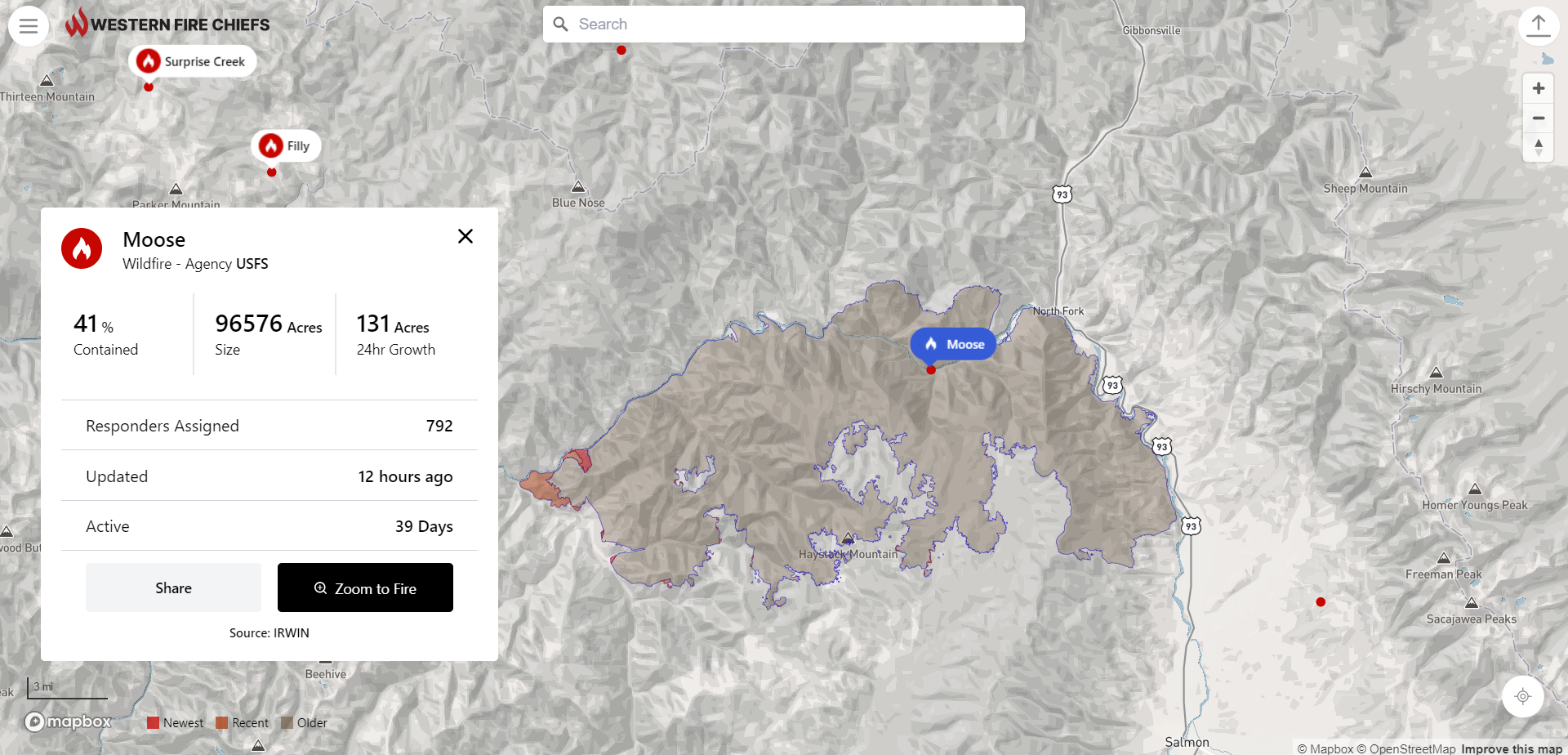
The WFCA Fire Map pulls data from the US Forest Service via National Interagency Fire Centre IRWIN feed and 911 Dispatch data via PulsePoint to track the location of the wildfire as they start and while they are burning. The WFCA Fire Map is the first map of its kind to pull this data from 911 Dispatch in relevant areas.

“The current climate situation is incredibly scary,” says Chief Mark Niemeyer, Vice President of the WFCA and Fire Chief of the Boise Fire Department. “The WFCA is providing public access to definitive information around the paths of wildfires so that communities can quickly take action.”

He continues: “The WFCA is committed to provide an even deeper level of intelligence around wildfires as they happen.” As the WFCA looks to the future, it is creating a development path in the next year which will include 3D and predictive mapping models, air quality and weather data, as well as text message notifications.

The Fire Map

The WFCA Fire Map was launched to provide near real-time information about active wildfires in a mobile[1]friendly platform. Brent VanKeulen, Deputy Director of the Western Fire Chiefs Association says the WFCA is providing the map to everyone free of cost, as a resource to save lives, land and property. He explains: “By providing public access to definitive information around the paths of wildfires, we are hopeful that communities can take quicker action to stay safe.”

 The WFCA Fire Map pulls together data supplied by the US Forest Service via National Interagency Fire Center IRWIN feed and combines it with 911 Dispatch data via PulsePoint. Together, this information is used to track the location of the wildfire both as it starts and whilst it is burning.

 The fire map was developed by Gartrell Group for the WFCA. Users can search for a fire by name, zoom to a location or zoom to their location and explore the area nearby. Where larger fires are mapped these will display the perimeter as changes are reported. Along with the map visualisation, the app provides details including fire size in acres, 24-hour growth, percent containment, number of personnel assigned, how long the fire has been active, and when the information was last updated.

The app features a share button and clicking this allows users to easily share information about a fire. There is also an embed option to link to a live map of the McKinney Fire. Users can click the fire symbol on the map to view information about the fire, and to share to social media. Other features such as weather and wind information are in the pipeline.

Looking ahead, the fire map in its current state is just the beginning. VanKeulen adds: “Wildfires will be a part of our lives for the foreseeable future. We will always have areas where people live in the forest. We need to focus on building adaptive communities so that we can be safe in the presence of fires. The WFCA and many other organizations are working towards solutions that help us adapt. The fire map is one of several initiatives.

PulsePoint

PulsePoint is a 501(c)(3) public non-profit foundation building applications created to help public safety agencies inform and engage their citizens. The development of the PulsePoint app began in June 2009 as a partnership between the San Ramon Valley Fire Protection District (SRVFPD), where its founder Richard Price was the chief, and the College of Informatics at Northern Kentucky University (NKU).

The application was released in the Apple App Store in April 2010. At a meeting almost a year later the Board of Directors of the San Ramon Valley Fire Protection District established a committee to address the affairs related to the application, including the transfer of responsibility for the software to an independent and external non-profit foundation. This resulted in the formation of the PulsePoint Foundation to oversee the future direction of the application.

In September 2013 the PulsePoint Foundation entered into a strategic partnership with Physio-Control, Inc. to expand the availability of PulsePoint to public safety agencies and on January 1, 2017, these responsibilities transitioned back to the foundation. Physio-Control became an invaluable partner that helped establish a presence in the market and helped prove the value of using mobile technology to activate early bystander response in sudden cardiac emergencies.

As the WFCA looks to the future, it is creating a development path in the next year which will include 3D and predictive mapping models, air quality and weather data, as well as text message notifications. “The addition of text notifications will be a game changer.” Richard Price, Founder PulsePoint.

“We are excited to offer the opportunity for PulsePoint[1]connected agencies to seamlessly display fire incidents within the WFCA Fire Map.”

This article was originally published in the September edition of IFSJ. To read your FREE digital copy, click here.